Anyone who knows me a bit, will know that my answer is «YES, BOTH ARE FUN!»I have always loved them (and anything else that can help me organize this world into something to remember and memorize!)
I can stare at a map for hours trying to figure out what to do, where to go and how to get there. When I am travelling or hiking I frequently pull the map out (or these days my phone!) just for fun. I mark where I have been, and save them for later trips or just as a nice memory.
Although I have held and owned many maps in my life, I have never made a map myself, and for sure not a underwater cave map. I was therefore immediately attracted to a GUE course called Underwater Cave Survey, where you among many other things also learn how to make an underwater cave map. Fun written all over it if you ask me!
My curiosity for underwater cave survey was further awaken after my GUE Cave 2 Course in Mexico two years ago. During that class students need to make a simple underwater cave map, and since our team head a great time doing it, I wanted to learn more about it. After doing my GUE Documentation Diver Course cave version in Sardinia in June last year, my passion for documenting and sharing the information about the underwater cave world increased. Since I was going to spend eight weeks cave diving in Mexico this year, I decided to sign up for a underwater cave survey class at the beginning of January.
There is only one GUE instructor in the world teaching this course – Fred Devos. His passion for exploring, surveying and diving shines through every little bit of the course, and really adds that perfect touch to the it. It is amazing and very inspiring to see how someone who has been diving and teaching for more than two decades still can look like a three year old child opening his presents on Christmas Eve after surfacing from a cave never surveyed before. Every time I do a GUE course I am beyond grateful to be able to learn from some of the very best this community has to offer.
These are the course outcomes as written on the GUE web page:
GUE’s Underwater Cave Survey Course is designed to introduce experienced cave divers to the important skill of surveying underwater caves. Among the course’s intended outcomes are: introducing divers to the basic principles of underwater cave survey, the implementation of a defined team approach to underwater survey data collection, preparing an experienced cave diver to assist productively in a coordinated cave project, and introducing divers to cartography methods.
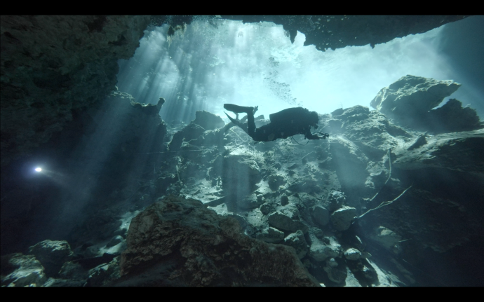
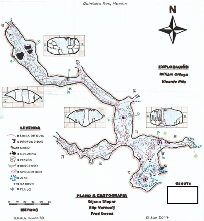
The class has only two students and lasts for five days. There is a bit of theory and some homework to be done, but the course is mostly practical involving both field drills and diving. We had a pleasure of surveying and mapping a cave that has never been surveyed and mapped before. Our instructor had actually never even dove it before! On our first field drill we learned how to perform a cave underwater survey in a safe manner as a team. The next few days we practiced this skill under water for several hours each day: checking depths, measuring distances, counting knots and taking azimuths for all the stations on the line. It may not sound like fun, but it makes you look at a cave in a whole different way. It can be compared to learning the anatomy of a human body compared to just looking at it as a whole. Swimming far off the line is not something we normally do on a regular dive, but now this was part of the job. And when you swim off the line, you notice things you normally do not. Bottom formations, type of rock, size of the cave, decorations, side tunnels, flow directions and so on. We learned how to sketch underwater on the next last day of the course, which added to the complexity of our map. This also forced us to move from the details to a bigger picture. It makes you think what parts of the cave are really important to see, remember and know about in order to make a map that can help other divers, people and/or scientists.
The weekend after the course we finalized our map using paper, color pencils and markers. We started off with a bunch of tables, numbers and lines, and ended up with, if I can say it myself, a pretty cool underwater cave map!
The drawing of maps is not normally done by hand in big projects, but I really liked learning how it used to be done before computers took over. It made us understand the whole process a lot more than if we had just plotted the numbers into a program, having the map «pop up».
Although I did read the outcomes of the course before signing up, I was not completely sure how the course would be, and if I would actually like it or not. At the end of the course, we both agreed that we had enjoyed it a lot more than expected and I can highly recommend it to anyone who is considering doing it. The week after the course we actually went back to «our» cave to survey another two jumps/tunnels that we did not have a chance to finish during the course (it takes a lot of time in the beginning). There is no way we would do this if we truly did not enjoy it.
Diving for me has for many years been about more than what I see while diving. Yes, I like the fish and I love the decorations and formations but my big motivation is also to provide data that can encourage conservation, add to research and enhance awareness about the underwater world (in this case caves). Of course, diving is also about having fun, sharing experiences with my team members and working together as a unified team. Surveying presents you with all of this and more!
Caves never stop to amaze me – there are filled with an endless amount of beauty, mystery and new details to discover. I know my cave survey certification will only increase my love for them, and hopefully contribute to letting them stay the way they are for many years to come!